

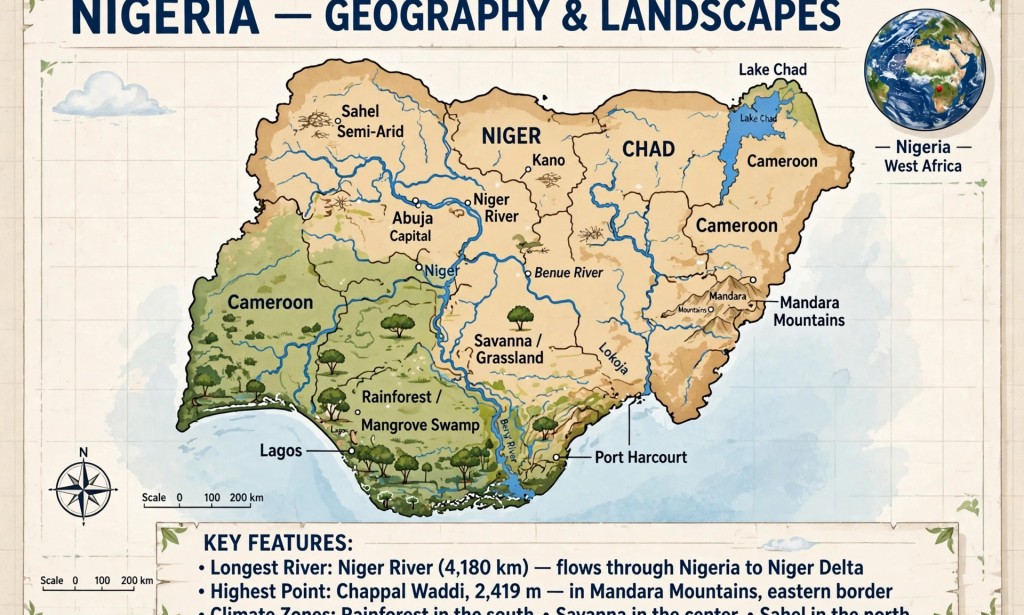
Nigeria is one of the most geographically diverse countries in Africa. Many people live in Nigeria but do not know interesting facts about its land, rivers, and climate. Understanding the geography of Nigeria is important for students, especially those preparing for WAEC and JAMB.
Here are seven interesting facts about the geography of Nigeria.
1. Nigeria Has Three Major Climate Zones
Nigeria is divided into three main climate zones. The South has rainforest and mangrove swamp with heavy rainfall throughout the year. The Middle Belt has Guinea and Sudan savanna with grasslands and scattered trees. The North has Sahel and semi-arid climate which is dry and close to the Sahara Desert. This is why it rains more in Port Harcourt and Lagos than in Kano and Sokoto.
2. River Niger is the Longest River That Passes Through Nigeria
River Niger is 4,180 kilometers long and is the third longest river in Africa. It flows from Guinea through Niger Republic and enters Nigeria through Kebbi State. It meets River Benue at Lokoja in Kogi State. This meeting point is called the Confluence. From there, it flows into the Atlantic Ocean through the Niger Delta.
3. The Highest Point in Nigeria is Chappal Waddi
The highest point in Nigeria is Chappal Waddi, also known as Mountain of Death. It is 2,419 meters above sea level and is located in Taraba State, close to the Cameroon border in the Mandara Mountains. Many Nigerians think Obudu or Jos Plateau is the highest, but Chappal Waddi is higher.
4. Nigeria Has a Coastline of 853 Kilometers
Nigeria has a long coastline facing the Atlantic Ocean, stretching from Badagry in Lagos State to Calabar in Cross River State. This coastline includes beautiful beaches, lagoons, and the Niger Delta, which is one of the largest wetlands in the world and rich in crude oil.
5. Jos Plateau is Cool Because of High Altitude
Jos in Plateau State is cooler than most parts of Nigeria. This is because it is located on a high plateau, about 1,200 meters above sea level. The rocks in Jos are also very old and contain tin. This is why Jos produces many of the Irish potatoes we eat in Nigeria.
6. Lake Chad is Shrinking
Lake Chad is located in the northeastern part of Nigeria, bordering Chad, Niger, and Cameroon. Fifty years ago, it was one of the largest lakes in Africa. Today, it has reduced by more than 90 percent due to climate change and low rainfall. This has affected fishing and farming in Borno State.
7. Nigeria Has Over 250 Ethnic Groups Linked to Geography
The geographical diversity of Nigeria influenced where different ethnic groups settled. The Ijaw people settled in the mangrove swamps of the South because they are fishermen. The Fulani people are mostly in the savanna of the North because it is good for cattle rearing. The Tiv and Igbo people are in areas with fertile soil good for farming yams.
Conclusion
The geography of Nigeria is rich and diverse. From rivers to mountains, from rainforest to Sahel, every region has unique features. As a student, when you understand these features, geography becomes more interesting and easier to remember. It also helps you appreciate the natural resources God has blessed Nigeria with.
Which part of Nigeria have you visited and what geographical feature did you notice? Share in the comment section.


You must be logged in to post a comment.